Data and Information
Generally, JPS provides data such as hydrological data, GIS data, river basin data, and coastal zone data.
Generally, applications for data and information can be made officially to the Corporate Division for the purpose of coordinating information sharing of the Department of Irrigation and Drainage (JPS) Malaysia. However, if the applicant has identified the type of data and information required, applications can be submitted through the following methods:
i. For hydrological data contained in the Fee Ordinance (Hydrological Data) 1966, Fee Act 1951 (Act 209), applications can be made online at http://sprhin.water.gov.my or manually through http://h2o.water.gov.my;
ii. For geospatial data, applications can be made online at http://spdg.water.gov.my/spd/login;
iii. Apart from hydrological and geospatial data, applications should be made officially through an official letter or email to the Director of the Corporate Division of JPS Malaysia.
The procedure for applying for data at JPS is as follows:
i. Applicants must fill in the following forms: a. Data Application Form
b. Certification Form
c. PPNM 1 Form (For GIS data applications)
ii. Applicants must also submit the following documents to JPS: a. Copy of identification card / copy of passport b. Completed relevant forms c. Summary of study report, thesis, and others (Introduction, Objectives, scope of study, methodology, etc.) d. Authorization letter and copy of identification card / copy of passport of the representative collecting the data (if applicable) e. Appointment letter from the Government for government projects (if applicable)
iii. Any additional information submitted to JPS is considered a new application.
iv. Applicants will be contacted once the information and data have been fully processed by this Department.
v. Only information and data approved by the Chief Information Officer (CIO) will be handed over to the applicant.
vi. Processed information and data will not be posted to the applicant. The information and data will be delivered by hand or email (if the data is small in size).
Yes, the application can be rejected by JPS for the following reasons:
i. The forms and documents submitted are incomplete.
ii. The feedback from the applicant is submitted late to JPS (exceeding 7 working days).
iii. The requested information and data are confidential and restricted.
iv. The application information is misleading.
v. The information and data are not available in JPS records.
vi. The application for information and data is for the benefit of certain parties.
vii. The individual, company, or university has been blacklisted by JPS previously.
viii. The certification form is not signed and stamped by a qualified person.
ix. The applicant did not submit copies of the study, report, thesis, etc., based on the data obtained from JPS after the study report, and so on, was completed previously.
Yes, it is possible to resubmit a rejected application if the previous application was rejected due to:
i. Incomplete forms and documents submitted.
ii. Late feedback from the applicant to JPS (exceeding 7 working days).
The responsibilities of the applicant after obtaining the data are as follows:
i. The applicant is not allowed to use the obtained data for purposes other than the original purpose stated in the application to JPS.
ii. The applicant is not allowed to share the data with individuals or other parties.
iii. The applicant may face legal action if they violate the Official Secrets Act 1972.
iv. The applicant must submit a copy of the study, report, thesis, etc., based on the data obtained from JPS after completing the study or report.
v. JPS reserves the right to request the applicant to present the results of their study, report, thesis, etc., based on the data and information obtained from JPS.
vi. JPS reserves the right to withhold some or all of the requested data.
vii. The applicant must provide an updated status of the study, report, thesis, etc., based on the data previously obtained from JPS before submitting a new application to JPS.
Mechanical and Electrical
The role of a tidal control gate is to regulate and prevent saline water (sea water) from entering upstream river areas, which can sometimes flow up to 10 kilometers depending on the river's water level, potentially affecting water use for agriculture. Additionally, tidal control gates also function to manage and discharge excess water that could cause flooding in the surrounding areas directly into the sea.
The operation of tidal control gates can be carried out in several ways. Here are some of the methods implemented at JPS:
i. Manual (hand wheel)
This method uses human effort, where the operator manually turns a 'hand wheel' on a 'gearbox' to open and close the tidal control gate.
ii. Semi-Auto (push button)
In this method, the operator must be on-site at the tidal control gate to open and close it by pressing a push button switch.
iii. Automation
The gate is controlled automatically through a pre-set program.
iv. Supervisory Control and Data Acquisition (SCADA)
The gate is controlled both automatically and remotely from a distance through a pre-set program.
The role of a dual-function control gate is to regulate water levels for both agricultural irrigation systems and flood drainage systems.
For agricultural irrigation, the control gate is closed to store water, especially during the dry season, and opened to release water for crop irrigation as needed. For flood drainage, the gate is opened to release water downstream. If the water level downstream is high, the control gate is kept closed to prevent water from flowing upstream.
A drainage pump house serves to transfer water from upstream areas to downstream areas to prevent flooding when water reaches flood levels.
A drainage pump house operates automatically when the water level in the reservoir or catchment reaches a specified threshold.
An irrigation pump house provides appropriately sized pumps based on the area of crops in a location. The pumps operate to supply water according to the agricultural needs of the area.
An irrigation pump house operates to supply water according to agricultural needs at a specific location, manually and seasonally.
Usually, portable pumps are installed when a flood occurs. However, in areas that frequently experience flooding, portable pumps are installed permanently for a longer period to reduce the impact of floods.
Environmentally Friendly Drainage
The Environmentally Friendly Drainage Manual (MSMA) is a guideline for engineers to plan urban drainage infrastructure using the concept of quantity and quality control at the source. This method is introduced to prevent flash floods, mud floods, and river pollution.
The MSMA document can be obtained for free by downloading it from the following web link: https://www.water.gov.my/jps/resources/PDF/MSMA2ndEdition_august_2012.pdf
ESCP is an Erosion and Sediment Control Plan implemented before land works begin. It aims to prevent soil erosion at construction sites and control sediment deposition into rivers and water bodies.
ESCP is required for all land works exceeding 1 hectare. For projects subject to an Environmental Impact Assessment (EIA), the ESCP must be prepared by a Professional Engineer with a Practice Certificate (PEPC) and a Certified Professional in Erosion and Sediment Control (CPESC) or equivalent.
It is recommended to construct quantity control structures for managing stormwater as follows:
i. Development Area < 1 hectare – Individual On-Site Detention Pond (OSD)
ii. Development Area 1 - 5 hectares – On-Site Detention Pond (OSD)
iii. Development Area 5 - 10 hectares – Dry Detention Pond
iv. Development Area > 10 hectares – Wet Detention Pond
The BMPs recommended in MSMA for quality control after development completion include trash traps, bioretention systems, swales, wetlands, and detention ponds
The design capacity requirements for flood detention ponds consider a major drainage system with a 100-year Average Recurrence Interval (ARI).
All BMPs for sediment control should be designed to capture 90% of sediment discharged from the construction site. Sediment traps should be designed with a 10-year ARI and detention capacity as specified in Table 10 of MS 2526-12:2014 Part 12 Erosion and Sediment Control.
Rainwater Harvesting (RWH) involves collecting rainwater from building rooftops or other specially constructed structures. The benefits of rainwater harvesting include:
i. Utilizing water resources towards sustainable development, especially in urban areas. This system can be applied for domestic, industrial, commercial, and agricultural uses.
ii. Providing an alternative water source for non-potable uses such as toilets and firefighting, which can help reduce treated water bills.
iii. Improving river management by reducing the flow rate to drainage systems, thereby decreasing erosion rates.
The Environmentally Friendly Drainage Master Plan (PISMA) is a master plan for drainage in a specific area that includes an analysis of the drainage system considering both existing and future land use. PISMA contains a drainage master plan for quantity and quality control in stormwater management. It also includes recommendations for addressing flash flood issues and stormwater pollution.
Maintenance of On-Site Detention (OSD) and detention ponds falls under either JPS (Department of Irrigation and Drainage) or PBT (Local Authorities), depending on the determination of the state government.
Quantity Surveying and Procurement
Companies interested in participating in JPS tenders/quotations must ensure they are registered with the Construction Industry Development Board Malaysia (CIDB) and have obtained the Contractor Registration Certificate (PPK) and the Government Procurement Certificate (SPKK) in the relevant grade, category, and specialization, as well as the Bumiputera Status Certificate (STB) issued by the Contractor Service Centre, Ministry of Entrepreneur Development and Cooperatives, if applicable. Companies should also ensure that these registration certificates are still valid.
Common specializations required for drainage and irrigation works include CE21, CE06, and CE40. Companies can check tender advertisements on the MyProcurement website - https://myprocurement.treasury.gov.my/ and the official website of the Department of Irrigation and Drainage Malaysia - https://www.water.gov.my/.
Flood Management
Flash flood is defined as a rapid rise in water levels caused by intense rainfall, resulting in flooding within a short period.
Short-Term: Carry out cleaning work for blocked drainage in the affected areas.
Long-Term: Implement Flood Mitigation Plan (RTB) projects to reduce flooding problems.
Information and monitoring of rainfall warnings and current water levels can be accessed via http://publicinfobanjir.water.gov.my.
The Flood Hazard Map is a map created using hydrodynamic modeling that shows the extent and depth of flooding based on specific recurrence intervals (ARI). In the context of JPS, this map is a key resource for assessing and translating flood risk when developing policies and strategies for flood management. It helps in:
i. Identifying potential flood mitigation project locations.
ii. Recognizing areas and locations affected by floods across the country.
iii. Estimating the impact and evaluating flood damage.
iv. Raising awareness and preparedness among residents to reduce flood losses.
v. Assessing and selecting flood evacuation centers.
The uses of the Flood Hazard Map include:
i. Planning flood mitigation structures.
ii. Analyzing flood hazard maps by integrating information from the Department of Statistics to determine the number of residents affected by flooding.
iii. Assisting the Department of Urban and Rural Planning in developing development plans through the National Structure Plan.
iv. Creating flood evacuation maps.
v. Developing flood insurance index maps.
vi. Preparing flood risk maps.
The RTB project implements flood mitigation initiatives as part of JPS's efforts to reduce flood risk to residents.
Flood mitigation is a method for addressing flooding caused by river overflow, while urban drainage deals with flash floods in urban areas.
River Basin Management
The guidelines applied for river sand mining applications are the "Guidelines for River Sand Extraction Amendments 2012."
The guidelines applied for any development applications involving rivers are the "Guidelines for Development Involving Rivers and River Reserves."
The scope of work involved in the JPS river conservation program includes:
i. Excavation work, including the removal of silt, deepening, and clearing obstructions, debris, solid waste, trees, and other materials in the river.
ii. Grass cutting and cleaning of riverbanks.
iii. Stabilization of riverbanks.
iv. Maintenance of immovable assets.
The public can apply to use river reserve land for agricultural purposes by submitting a letter of application along with the location details to the District and Land Office. The decision on whether to approve the application is under the jurisdiction of the District and Land Office. However, applications for long-term crops and permanent structures are not permitted.
Yes, you can. However, you must first obtain permission from the JPS authorities.
Yes, you can, provided you first obtain permission from the JPS authorities.
No, the enforcement of laws related to river pollution falls under relevant enforcement agencies such as the Department of Environment, Local Authorities, the National Water Services Commission (SPAN), and the Land and Mines Office.
Yes, you can. However, if the sand extraction is for commercial purposes, you must apply to the Land and Mines Office and the State Authority.
The width of the river reserve required by the Department of Irrigation and Drainage (JPS) for a lot application depends on the existing width of the river.
Yes. All river maintenance falls under the responsibility of the State Department of Irrigation and Drainage.
River reserve areas are very important to the Department of Irrigation and Drainage (JPS) for the following purposes:
i. Floodplains (for erosion control and allowing river meandering)
ii. Maintenance of rivers and buffer zones for flora and fauna breeding

Hydrology
The hydrological data provided includes rainfall data, water levels, evaporation, sedimentation, river flow rates, and water quality.
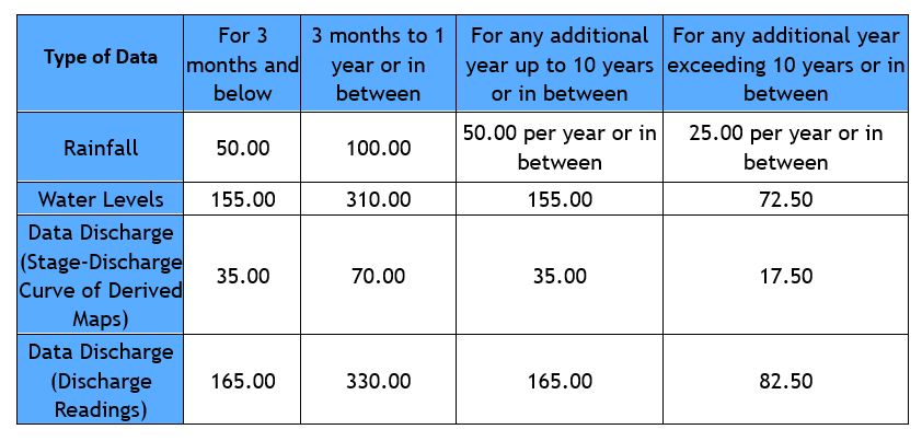
In general, the Department can impose charges for requests for hydrological data, except for government projects, research, and academic purposes. The charges for private projects are based on the Fees Order 1966, as shown in the table below.
Payment for hydrological data can be made using Postal Orders, Money Orders, Bank Drafts, or CIMB Clicks. Payment should be made to the Director General of JPS Malaysia for Hydrological Data purposes.
ePayment for requesting hydrological data is available only for CIMB Bank account holders. The procedure via internet banking is as follows:
Log in to your CIMB Clicks personal account.
Click on Pay Bills in the left menu.
Select the Department of Irrigation and Drainage Malaysia from the PAY IN LIST.
Enter:
Name
Company/IC Number
Amount (RM)
Click CONFIRM to submit your request.
Click PRINT to print the receipt.
The receipt is required as proof of payment.
As stated in the Drought Operational Procedures published by the Majlis Keselamatan Negara (MKN), JPS is responsible for reporting the status of river flow rates and reservoir storage.
Reports on the status of reservoir storage and river flow rates can be accessed through the Infokemarau website at www.infokemarau.water.gov.my. JPS also provides information related to drought warnings for a 14-day period and drought forecasts for a 2-month period for selected river basins, which can be accessed at www.nawabs.water.gov.my.
There are two methods for collecting rainfall data:
i. Manual (Logger): Data is collected manually by state JPS staff. This data is reviewed before being archived into the database.
ii. Telemetry System: Data is recorded and transmitted in real-time and online. This data is used for monitoring, forecasting, and flood warnings, and is stored in the public sector database.
Hydrological data is used for purposes such as:
i. Designing civil engineering facilities (e.g., roads, bridges, dams, buildings, tunnels, power stations, irrigation systems, flood control, etc.)
ii. Research (e.g., universities, consultants, students, etc.)
iii. Flood forecasting and warnings
iv. Drought forecasting and warnings
v. National hydrological data archiving
i. To develop a system capable of forecasting monsoon flood events up to 7 days in advance based on weather forecast data from the Malaysian Meteorological Department (MetMalaysia).
ii. To enhance the flood warning and notification system from 6 hours to as early as 2 days for relevant agencies and residents affected by floods.
iii. To improve the accuracy of flood predictions by reducing the discrepancy between forecast data and actual water levels from more than 1 meter to less than 0.5 meter.
Irrigation
Yes, provided you obtain permission from JPS first.
The frequency of agricultural ditch excavation work conducted by JPS is typically carried out periodically every 3 to 5 years. However, this depends on current conditions and financial allocations.
No, you cannot. However, if any construction is to be done, you must submit an application and obtain written permission from JPS and the relevant authorities.
Yes, you can. The applicant must submit a request to JPS, and the road must be constructed according to JPS/JKR specifications.
Beach

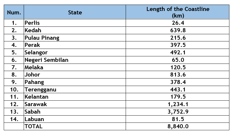
The length of the coastline experiencing erosion throughout Malaysia is 1,347.6 km. The erosion is divided into three categories:
Category 1: Critical (erosion exceeding 4m per year) = 55.4 km
Category 2: Significant (erosion between 1m and 4m per year) = 375.9 km
Category 3: Not Serious (erosion less than 1m per year) = 916.3 km
The development setback limits in coastal areas according to the National Coastal Erosion Study (NCES) 2015 are:
i. For coastlines experiencing Category 1 erosion = 60m from Mean High Water Spring (MHWS)/High Water Line
ii. For coastlines experiencing Category 2 erosion = 30m from Mean High Water Spring (MHWS)/High Water Line
iii. For coastlines experiencing Category 3 erosion = 20m from Mean High Water Spring (MHWS)/High Water Line
iv. For coastlines with mangrove forests = 400m from the seaward edge of the mangrove forest (Development is not allowed if the mangrove forest area is gazetted as a permanent forest reserve under the National Forestry Act 1984)
Generally, sand mining activities are not permitted in areas located less than 1.5 km from the Mean Low Water Line or 10 meters in water depth measured from the Lowest Astronomical Tide, whichever is further from the shoreline.
Management Services
Applications can be submitted in writing to the Director of the Management Services Division, Department of Irrigation and Drainage Malaysia or by email to uruspsm@water.gov.my.
Complaints
Issues related to piped water supply are managed by the Bahagian Bekalan Air WP Labuan (BBA).
Complaints should be directed to the Local Authority (PBT). Section 50 of the Road, Drainage, and Building Act (Amendment) 193 (Act A867) states that the Local Authority (PBT) is responsible for constructing and maintaining ditches and water channels.
Complaints regarding river pollution can be referred to the Jabatan Alam Sekitar (JAS). JPS is responsible for the periodic maintenance of rivers.
Complaints can be made through the Sistem Pengurusan Aduan Awam (SISPAA) at https://water.spab.gov.my/eApps/sdmscasepool/SdmsCasePool/add.do or by directly contacting JPS at 03-2616 1500.
